Fournet-Blancheroche
plan haut-doubs montagne du jura
 Plan d’accès du Domaine de l’Authentique à Fournet Blancheroche, Altitude 911 mètres
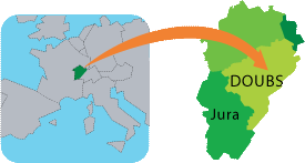 Plan d’accès du Domaine de l’Authentique à Fournet Blancheroche, Altitude 911 mètres
BESANCON = 73 KM
MONTBELIARD = 54 KM
PONTARLIER = 56 KM
CHARQUEMONT = 6 KM – PHARMACIE et MEDECINS.
MAICHE = 12 KM – OFFICE DU TOURISME DU PAYS HORLOGER.
LE RUSSEY = 9 KM
MORTEAU = 25 KM
FRONTIERE SUISSE BIAUFONDS = 7 KM
GARES : Besançon Viotte (TGV) : 73 km – Franes (TGV) : 71 km.
En Suisse : La Chaux de Fonds à 19 Km, Neuchâtel à 40 km.
AEROPORTS : Genève-Cointrin à 2 heures de route. Mulhouse- Bâle à 1h30 mn.